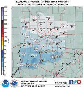
A quick-moving area of low pressure passing south of Indiana is expected to produce accumulating snowfall across the southern half of the state later this afternoon and into the early evening
hours. Snowfall is expected to begin after 200 PM. Accumulations of 1 to 2 inches will be possible along and south of a Terre Haute to Martinsville to Greensburg line, with lesser amounts farther north.
The snow may result in reduced visibility to one-half mile, along with slick and snow covered roads, including during the evening rush hour. Use caution if traveling this afternoon and evening. Be prepared for rapid reductions in visibilities and changeable road conditions.


